– Climate Change is Water Change –
The Colorado River Basin is a defining feature of the American Southwest and is one of the most critical sources of water in the region. The river borders seven states, two nations, and dozens of Native American reservations such as the Navajo Nation, the White Mountain Apache Nation, and the Hopi Tribe. The Colorado River Basin has shaped the face of the region, supporting a multi-billion-dollar recreation industry and providing life-giving flows to the nation, its adjacent regions and across the country. But this lifeblood of the southwestern United States is facing an increasingly alarming problem: it is just too hot.
The region is used to droughts, but an increase of temperatures will manifest itself in an increase of drought duration and frequency over the next fifty years, as well as a 9 percent decrease of natural river flow in the same time frame. In the next fifty years, droughts lasting five years or more are expected to occur 50 percent of the time. These will go from what would have been moderate droughts into severe ones, known as “hot droughts.” The current drought the Basin is experiencing is unprecedented because increased air temperatures are leading to decreased flow, whereas river flows have historically been affected by changes in precipitation.
Coupled with this increased dryness of the region, it is predicted that the Basin will experience a temperature rise of an additional five degrees Fahrenheit by 2050. The rising temperatures and decreasing water levels will impact almost all areas of human life. For instance, rising temperatures will affect the need to meet peak summertime demands in urban areas, the demand upon winter needs in mountain resort towns, and the availability of water for agricultural producers. The impact of climate change will also affect local wildlife; reduced water levels could lead to up to 75 percent of local fish biodiversity heading toward extinction by 2070.
The Impact of Climate Change on Reservoir Levels
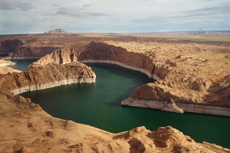
In addition to depleting habitats for the Basin’s aquatic species, climate change has negatively impacted the water levels of the Basin’s reservoirs. Water levels in Lake Mead and Lake Powell, two of the Basin’s main reservoirs, have been falling for decades; what is left is “bathtub rings” of mineral deposits, leaving a harsh reminder of what they used to be.
Between 2001 and 2015, Lake Mead’s elevation dropped from approximately 1,200 feet to 1,075 feet. In addition to the mineral deposits being visible along the shoreline, the declining reservoir level exposed Hoover Dam’s four intake towers. These towers channel the water from the reservoir into penstocks that serve the Dam’s seventeen hydroelectric towers. As the water moves through the generators and gets released back into the river, electricity is created. The Bureau of Reclamation (Bureau) estimates that for every one-foot drop in elevation in Lake Mead, Hoover Dam’s electricity capacity is reduced by just under six megawatts. Out of necessity, the Bureau has alleviated some of the burden by replacing traditional turbines with “wind-head” turbines, which can generate electricity at lower reservoir elevations using the wind.
At Lake Powell, the falling reservoir levels affect the generating capacity of the Glen Canyon Dam powerplant. Below an elevation of 3,490 feet, the reservoir cannot produce electricity, and at an elevation lower than 3,375 feet, the reservoir is considered a “dead pool,” because water cannot flow downstream. The Bureau updates it’s five-year Probabilistic Projections of the river’s future conditions every January, April, and August. While Lake Mead currently has less than a 10 percent chance of hitting its minimal threshold of 950 feet by 2026, Lake Powell likely faces a dryer future. The Bureau projects a roughly 25 percent chance that Lake Powell will fall below its minimum by 2026.
The Supply and Demand Problem
This is not the first time the Colorado River has faced difficulty meeting demands. Following the region’s rapid population increase in the early twentieth century, the river’s border states established the Colorado River Compact of 1922. This Compact sought to make an equitable division of the Basin, contractually binding the states to share and apportion the water. The Compact created an Upper Basin and Lower Basin. The Upper Basin is comprised of the parts of Arizona, Colorado, New Mexico, Utah, and Wyoming from which the river’s water naturally drains into the System above Lees Ferry in Marble Canyon, Arizona. The states comprising the Lower Basin are the parts of Arizona, California, Nevada, New Mexico, and Utah to which water drains naturally into the Colorado River System below Lees Ferry.
The Colorado River Compact is the cornerstone of a system known as the “Law of the River.” The Law of the River is comprised of an international treaty between the United States and Mexico, two interstate compacts like the Compact, the historic 1964 U.S. Supreme Court decision of Arizona v. California, and several dozen federal statutes and regulations. The effects of climate change will impact the delicate supply and demand balance over the next fifty years, making it difficult for Upper Basin states to meet their contractual obligations, and, therefore, putting an onus on the Lower Basin states.
Both the river and the Law of the River have entered a critical point in recent decades. The demand for water in the Basin has exceeded supply on an annual basis since the early-to-mid-2000s. Because most of the Basin's water supply comes from the Upper Basin, drought conditions in the Upper Basin impact water supply and resources in both the Upper and Lower Basins. Roughly 92 percent of the river’s natural flow comes from runoff upstream of Lees Ferry, but natural flows into this dividing point declined between 2000 and 2015 to levels lower than any observed over the past century and some of the lowest over the past 1,200 years, based on paleo records. Natural flows are the streamflow that would have occurred without the intervention of human activity, such as reservoirs and dams, and river diversion.
Climate change has led to higher temperatures and an increasingly arid region. Paired with population growth, the demand of water in the river has swelled while the supply has steadily decreased. When the Colorado River Compact was created, both the Upper and Lower Basins were allotted 7.5 million acre-feet (maf) of consumptive use per year. At the time, the average annual flow in the Upper Basin was around 18.0 maf. However, the average flow into the river in the early twentieth century was an unusually wet period, whereas the average flow into the river in the following one-hundred year period was roughly 16.4 maf. Between 2000 and 2015, the average natural flow in the Upper Basin dropped to around 14.8 maf.
The Colorado River Basin has been described as “a river no more” with significant flows consistently failing to reach the river's delta in the Gulf of California for half a century. Even though rainfall and snowpack high in the Rocky Mountains were at near-normal levels in 2021, the dry soil and plants, shocked by the consistent intense heat, absorbed most of the water. Accordingly, inflows to Lake Powell were around 25 percent of their usual amount.
Most of the runoff leading into Lees Ferry comes from melting snowpack, but due to the warming and drying of the region, snowpack levels will decrease. While it is difficult to project future precipitation levels and patterns, a settled finding is that would-be snowstorms will become rainstorms, contributing to decreasing snowpack levels. It is not only humans who will feel the impact of decreased snowpack; higher temperatures and lower water levels will severely impact the demand to keep necessary stream flows critical for fish and other aquatic species.
The Impact of Climate Change on Fish Population Levels
Fish species native to the Upper Basin were historically more numerous, longer-living, larger, and their habitats were farther reaching than they are today. Climate change has led to milder winters, earlier spring warming, and warmer summers in rivers. Fish are uniquely sensitive to fluctuations in temperature and precipitation because of their confinement to aquatic habitats, and their ability to move to alternative habitats are generally more restricted than terrestrial species. An increase in the severity and frequency of droughts will lead to increased aridity and reduced streamflow in the region, creating a catastrophic impact on local biodiversity.
As habitats grow smaller due to increasingly arid climates, species’ ranges are changing, causing the establishment or expansion of nonnative species. For example, the humpback chub evolved in its Basin habitat without any native predators. Therefore, it is not well-adapted to living with nonnative species that have been introduced to its habitats because of climate change. The impact of ongoing climate change is projected to continue, leading to an increased risk of nonnative fish migration among humpback chub populations. As a species maladapted to this possibility, the potential establishment of nonnative species will exacerbate negative interactions between the humpback chub and nonnative species such as the smallmouth bass.
Conservation of the humpback chub is coordinated by three principal programs that consist of stakeholders from federal, state, private, and tribal interests. The issue, however, is that these recovery efforts are not legally binding or mandatory, but rather just statements of intention. Additionally, the recovery plans are inflexible and unable to be adapted as new data research becomes available.
While it’s impossible to predict the exact impact climate change may have on species like the humpback chub, it will likely reduce reproduction in humpback chub populations. So, what is the solution? Numerous ideas have been proposed, from new water apportionment schemes to water bank systems. Whatever the answer, it will have to be both a national and international effort. The Colorado River Basin’s depleting water levels impact more than those who live alongside the river, and whatever is decided upon will have to include the interests of a diverse range of local, interstate, and international policies, economies, and politics.
Perhaps the most viable option to save the river is to reevaluate the agreed-upon Basin allotments from the original Compact and declare new apportionment levels. It is difficult to say with certainty what the impact of climate change will be on the region; however, it is clear that the amount of available water in the Basins will only continue to decrease. While the Law of the River has a history of adjustment and has been updated as needed, future efforts will require coordination on a local, federal, and international scale, which is a daunting task. Adjusting the apportionment of the Basins will allow each state to share the burden equally while ensuring the continuation of their water rights. It will also force states to explore more sustainable sources of power such as wind or solar energy. The unfortunate truth is that the river can no longer be considered a renewable resource, and as the planet continues to experience the effects of climate change, we need to ensure the Colorado River doesn’t become another casualty. After all, to preserve this hallmark of the American West is to preserve its unparalleled cultural, historical, and scientific value.
SOURCES
Abrahm Lustgarten, 40 Million People Rely on the Colorado River. It’s Drying Up Fast., ProPublica (Aug. 27, 2021), https://www.propublica.org/article/40-million-people-rely-on-the-colorado-river-its-drying-up-fast (last visited Jan. 25, 2022).
Arizona v. California, 376 U.S. 340, 84 S. Ct. 755 (1964).
Climate Change in the Colorado River: What We Already Know, Colo. River Research Grp. (Oct. 2016), http://www.riversimulator.org/Resources/Academic/CRRG/2016.10.ClimateChangeColoradoRiverWhatWeAlreadyKnow.pdf
Drought in the Colorado River Basin, U.S. Dep’t of the Interior, https://www.doi.gov/water/owdi.cr.drought/en/ (last visited Feb. 8, 2022).
Emily Halvorsen, Compact Compliance as a Beneficial Use: Increasing the Viability of an Interstate Water Bank Program in the Colorado River Basin, 89 U. Colo. L. Rev. 937 (2018).
Friends of Blackwater v. Salazar, 691 F.3d 428 (D.C. Cir. 2012).
Henry Fountain, In a First, U.S. Declares Shortage on Colorado River, Forcing Water Cuts, N.Y. Times (Aug. 16, 2021), https://www.nytimes.com/2021/08/16/climate/colorado-river-water-cuts.html (last visited Jan. 25, 2022).
Jada F. Garofalo, Toward Holism, Aligning the Science and Policy of Recovery Planning for the Endemic Fishes in the Upper Colorado River Basin, 42 Environs: Env’t. L. & Pol’y J. 147 (2019).
Jason A. Robison & Douglas S. Kenney, Equity and the Colorado River Compact, 42 Env’t. L. 1157 (2012).
Jason Anthony Robison, The Colorado River Revisited, 88 U. Colo. L. Rev. 475 (2017).
Lake Mead and One of Hoover Dam’s Intake Towers. Bureau of Reclamation, Creative Commons.
Lower Colorado Region: 5-Year Projections, Bureau of Reclamation (Feb. 4, 2022) https://www.usbr.gov/lc/region/g4000/riverops/crss-5year-projections.html.
Mackenzie O'Donnell, Restoration of the Colorado River: Not a Minute to Spare, 42 Suffolk Transnat'l L. Rev. 413 (2019).
Tribes, On the Colo. (2020), http://www.onthecolorado.com/resources.cfm?mode=section&id=Tribes.
U.S. Dep’t of interior: Bureau of Reclamation, Colo. River Basin Water Supply and Demand Study (Dec. 2012), https://www.usbr.gov/watersmart/bsp/docs/finalreport/ColoradoRiver/CRBS_Executive_Summary_FINAL.pdf.